Assessment and Application of Beach Quality Based on Analytic Hierarchy Process in Yangkou Beach, Qingdao
2023-03-17LIHaimengWANGJingyiandZHUChaoyue
LI Haimeng,WANG Jingyi, and ZHU Chaoyue
Assessment and Application of Beach Quality Based on Analytic Hierarchy Process in Yangkou Beach, Qingdao
LI Haimeng1),WANG Jingyi1), *, and ZHU Chaoyue2)
1)International School, Beijing University of Posts and Telecommunications, Beijing 100876,China 2)College of Marine Geoscience, Ocean University of China, Qingdao 266100, China
The whole-beach quality assessment is the basis of building and preserving beautiful beaches. The beach quality assessment index system and assessment standard have been established based on the attributes of beaches (including the width, slope, landform, and types), sorting coefficient, and softness degree of surface sediment. The assessment weight of each index for quality evaluation was analyzed using the analytic hierarchy process, and comprehensive scores of selected beach profiles were calculated in accordance with the light assessment standard. A beach quality evaluation model based on index weight and scores was established in this paper. The factors of 12 profiles of Yangkou Beach in Qingdao City were surveyed to carry out a quality assessment, and the comprehensive scores of each profile were calculated in accordance with the evaluation model. The results showed that the quality of Yangkou Beach can be divided into four ratings: excellent, good, medium, and poor. The excellent-quality area includes a wide and flat dry beach zone and soft, flat, and clean intertidal and subtidal zones covered with well-sorted fine sand, and leisure sports, such as volleyball, running, and swimming, are suitable for tourists. The good-quality area features a slightly narrow and dry beach zone, moderately soft and uneven intertidal and subtidal zones covered with fine sand and a small tidal gully, and a small amount of foreign matter; leisure sports, such as walking and running, are suitable for tourists. This study recommends the building of fixed drainage ditches or underground culverts to reduce the tidal gully. The medium-quality area consisted of a narrow and dry beach zone, moderately soft and uneven intertidal and subtidal zones covered by poorly sorted medium sand, a tide ditch, and a small amount of foreign matter. In this area, walking is suitable for tourists. Sand should be supplemented in the intertidal zone. The poor-quality area contained a very narrow and dry beach zone covered with poor-sorted gravel, a very chaotic intertidal zone with a considerable amount of foreign matters, such as bricks and rocks, wide tidal ditches, and an uneven subtidal zone with some reefs; leisure sports are unsuitable here. Thus, foreign matter and reefs should be removed, and the dry beach zone should be supplemented with sand. Therefore, the beach quality assessment is a very useful tool for building beautiful beaches.
Yangkou Beach; assessment index; analytic hierarchy process; weight; quality zoning
1 Introduction
As the last barrier of transition from ocean to land, the coastal zone is the original place where people explore and study the ocean. The beach is an important part of the coastal zone and is usually developed in bays composed of rocky coasts. The wave is surging and magnificent, like ten thousand galloping horses on the rocky coast, but it is calm and sparkling in the bay. Beach sceneries are beautiful and have become an ideal place for people to enjoy life, release tension, and inspire thinking. Therefore, beaches have also become an important destination for coastal tourism. However, unknown dangers, such as sudden topographic change, rough high waves, rip currents, and flood tide, have been recorded on beaches (Short and Hogan, 1994; Scott., 2011). Statistics showed that 619 beach tourist safety accidents in China’s coastal areas from 2001 to 2019, and 1141 people (inclu- ding 660 drowned and missing) were involved (Lu., 2021). The beaches along the sandy coastline of more than 5000km in China cannot be opened to tourists due to unmet safety standards. The research result indicated that the safety factors affecting beach opening were the quality of seawater, cleanliness of sand, social security, and marine environment (Penn., 2016), which also provide guidance for the improvement of beach quality (Micallef and Williams, 2004). Beach quality has become an important factor that must be considered (Roca., 2008). A good beach quality is conducive to maintaining the sustainable development of coastal zones and improving the competitiveness of beach tourism.
Beach quality assessment has gradually become an important research field with the development of the social economy (Houston, 1996; Hall, 2001; Klein., 2004). People with good economic conditions have leisure time to go to the field; the beach is often the preferred destination for field trips. However, an introduction or directions about the quality assessment of beach destinations is a primary concern for finding the best beach before people set off. Some beach quality assessment standards have been put forward due to social needs in the United States, Britain, Australia, and other western developed countries (Lee, 1994; Nelson., 2000; Micallef, 2003; Micallef., 2004; Bombana, 2019; Fernando and María, 2022). A relatively perfect beach quality assessment and a rating system were researched in France in 1985 for the assessment of beach water quality, and the European ‘blue flag’ assessment standard, including 29 assessment indexes in four aspects (environmental education and information, environmental management, and safety service), was formed gradually. By 1992, Keep Britain Tidy proposed the beach awards and rating systems, which included 29 and 13 assessment cri- teria from six aspects: water quality, beach and intertidal zone, safety, management, cleanliness, information, and education, and used them to evaluate beach resorts and rural beaches (Morgan, 1999). Based on the degree of beach development, the University of Glamorgan established a beach quality standard by comprehensively considering natural, biological, and cultural factors (Williams., 1995; Nelson., 2000). The Costa Rica assessment system designed by Chaverri selected six groups of 113 assessment factors; this assessment is considered an assessment system despite the processing of most assess- ment factors and the use of the most complex scoring standards (Cgilaba., 2005). Some one considered the factors affecting the coastal landscape as assessment factors. From the assessment method, they focus on questionnaire surveys to obtain the perceived data of beach users and pay more attention to the economic value and user satisfaction of beaches (Nelson., 2000, Ludovic-Alexandre., 2021). A number of beach assessment standards and index systems that focus on the integration of beach water quality, service, and management of beaches (Botero., 2015) have been established. However, a mechanism for the improvement of beach quality remains a topic to be discussed.
In the past, China has been committed to solving the problem of food and clothing, but funds for beach development were lacking. The people’s demand for tourism has become stronger with the improvement of the economic level since the 18th CPC National Congress, and beaches have gradually become tourist spots. This new demand led to the vigorous development and protection of beaches. The study of beach quality evaluation and standards is gradually emerging; the quality rating of bathing beaches of the first, second, and sixth Shilaoren in Qingdao was evaluated by comparing natural characteristics, such as beach width, seabed inclination, current velocity, and wave height, as reported by Zheng. (1998). A beach-tourism resource quality assessment system with 80 assessment factors has been established by Li. (2000). The suitability of multiple bathing beaches using the analytic hierarchy process (AHP) based on the natural beach factors has been evaluated by Liu. (2009). Yu (2011) put forward a standard system including 54 factors in natural and socio-economic categories and divided six beaches in Shandong and Fujian into five grades, namely, ‘unqualified’, ‘copper’, ‘Silver’, ‘gold’, and ‘diamond’, after discussing the rating system of beach quality standards in China. Wang. (2017) constructed an assessment system after selecting appropriate factors by summarizing China’s national conditions and the characteristics of beaches, and it was applied to assess 32 beaches south of the Shandong Peninsula. Li (2017) and Gao (2019) established a beach quality assessment index system based on 19 indexes from the perspective of tourists by means of a questionnaire survey. The beach quality assessment was considered a complex problem affected by many aspects and levels. The natural attributes of beaches are the basic factors of beach quality and the premise and foundation of development (Suciu., 2017). Beach quality is often assessed from three aspects, including natural, environmental, and social attributes.Such an assessment is limited to guiding the quality improvement of a certain beach, and a system of beach quality assessment should become the guide of improvement with the intensification of beach research (Gisela., 2017). The Yangkou Beach in Qingdao city, Shandong Province, was not opened to the public until July 1, 2019, because of beach quality, which needed to be improved furtherly to attract more tourists. Beach quality zoning for the corresponding improvement is considered a good method. Therefore, the quality assessment system of whole beaches based on a multi-section natural factor survey was established. AHP was used to determine the weights of factors influencing beach quality, and a quality zoning was obtained. In this paper, corresponding repair suggestions were put forward based on quality defects.
2 Study Area
Yangkou is located in Wanggezhuang town, which is famous for steamed bread, at the foot of Laoshan Mountain on the south coast of the Shandong Peninsula. Many tourists visit the place due to its superior geographical location and the convenient transportation. Notably, this place between the Laoshan Mountain and Fengshan Mountain was once flooded by sea water before the late Pleistocene. The longtime filling-in of weathered debris from the mountain rocks on both sides led to the appearance of land and the formation of a bay at the south end of Fengshan Mountain (Fig.1). A beach with a length of about 1.5km and a width of about 100m and opening to the east formed gradually at the top of Yangkou Bay under the action of ocean dynamics. The sediment supply of the beach should be insufficient, as inferred from the large beach slope and coarse sediment particles in the past. The natural balance of the beach has been disrupted, and sediment transport has been blocked due to aquaculture ponds on both sides of the coast for decades. In recent years, the aquaculture ponds have been demolished to restore the marine ecological balance, and the beach was improved through artificial beach nourishment. However, many shortcomings remain to be addressed.
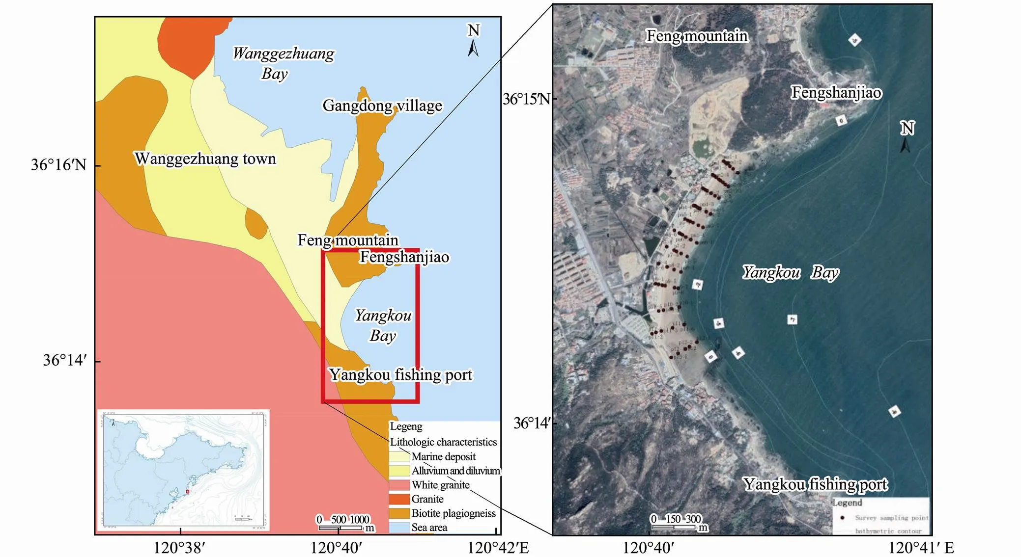
Fig.1 Location, geological characteristics, and survey station of the study area.
3 Methodology
3.1 Selection of Assessment Factors and Survey Results
This paper mainly considers the quality assessment of Yangkou Beach from natural factors. Twelve observation profiles were arranged on the 1.5km-long beach at an interval of approximately 100m, and the elevation measurement and surface sampling of the dry beach zone and intertidal zone in spring tide were carried out, respectively. To understand the seasonal dynamic changes in the beach, we observed the beach profiles in summer and winter. The water depth was obtained from the latest chart. Fig.1 shows the observation profile and sampling station. The particle size of samples was analyzed by the sieving method, and the sorting coefficient (uniformity of sand particles) of all stations was obtained. The names of samples were determined by the Shepard naming method. Through the processing of elevation data, the width, slope, geomorphic characteristics, beach foreign bodies, and dynamic changes of each profile of dry beach, intertidal zone, and subtidal zone were obtained. The test results are shown in Tables 1-3.

Table 1 Field survey data of dry beach zone
3.2 Decision Analysis Method for Complex Problems
The beach quality is affected by many factors with different contributions (Bombana and Ariza, 2018; Hu, 2020). The weight of each factor must be determined during decision-making. The weight is the value used to measure the influence degree of each index, and it is a subjective and fuzzy concept but requires an accurate method to describe. To increase the scientificity and reduce the subjectivity of the assignment, this paper used the hierarchical method to determine the weight of fac- tors (Vidal., 2011; Che., 2020; Shadmaan and Islam, 2021; Díaz., 2022; Panchal., 2022). The method aims to quantitatively assign relative weights to the criteria that affect a complex decision. The decision is usually based on the perception of the individual who is supposed to make the final decision and assess priorities (relative weights), emphasizing the importance of consistency and correlation of alternatives that have been compared in the whole decision-making process. However, it also utilizes a qualitative hierarchy to achieve such a goal. First, the method divides the constituent elements of the target problem into interrelated and orderly levels to form a multi-level structure. Then, with the establishment of a judgment matrix, the relative importance of the constituent elements of each level is marked by experts, who only need to compare and judge two factors each time. The ratio of the importance of two factors is determined using the 1–9 scale method, which can improve experts’ grasp of the importance of factors and reduce the difficulty of expert evaluation. Third, by calculating the maximum eigenvalue of the judgment matrix and the corresponding orthogonalized eigenvector, the weight of elements of this layer for the criterion is obtained. On this basis, the final weight of elements of each layer for the overall goal is calculated. Finally, the problem is analyzed and solved by the result ranking.
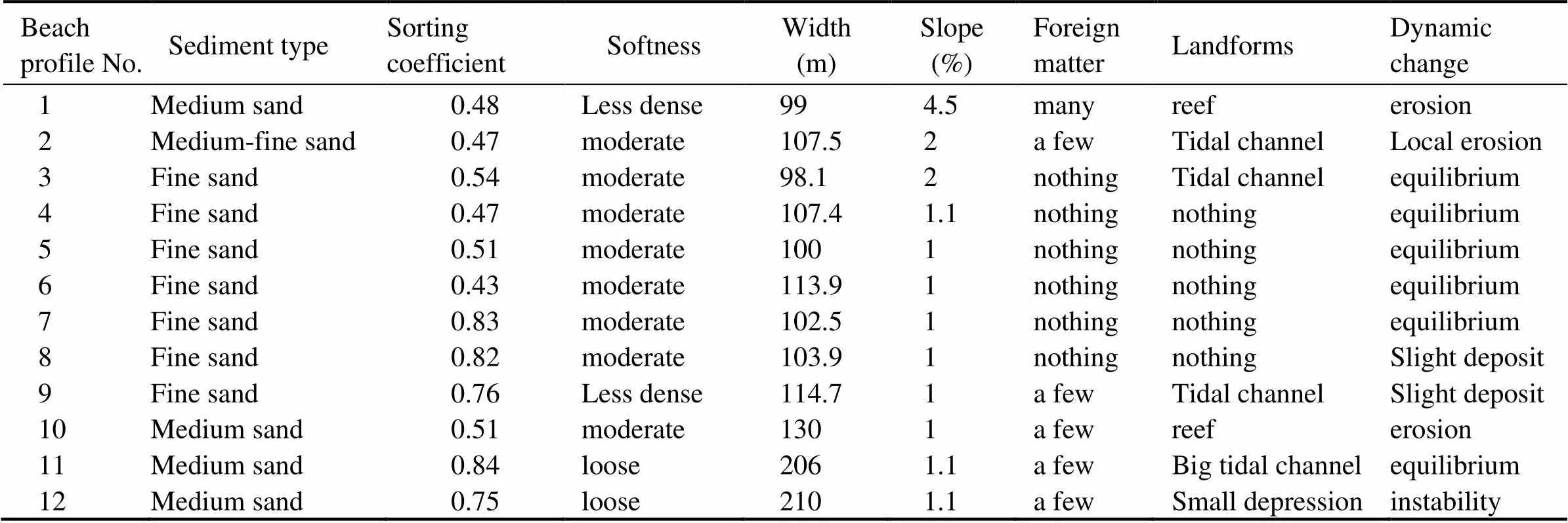
Table 2 Field survey data of intertidal zone
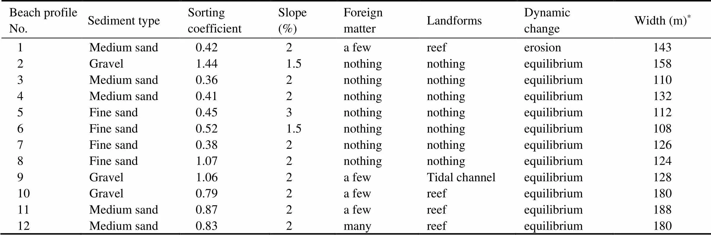
Table 3 Field survey data of subtidal zone
Note:*Refers to the distance from the mid-tide line to the 1.5 m water depth line.
4 Construction of Assessment System
4.1 Selection of Assessment Factors
The quality assessment factors of beaches at home and abroad generally include three aspects: 1) natural factors, including beach length, width, slope, grain diameter, reef, and split flow; 2) environmental factors, such as temperature, water quality, environmental cleanliness, red tide, landscape, and wildlife (harmful); 3) social factors, including convenient transportation, life-saving facilities, public facilities, accommodation and catering, tourist density, pet management, and amusement facilities. Environmental and social factors are the same in the quality assessment for the whole beach with a high degree of development, but the natural attributes of different regions that affect the local beach quality may vary. In terms of natural attributes, the typical sandy beach profile is divided into backshore, foreshore, near shore, and inshore by coastline, high-tide line, low-tide line, and wave baseline (Fig.2).
The backshore of the coastal accumulation plain is located above the mean spring-tide high-tide line to the artificially solidified road, building, or vegetation boundary, which is unaffected by seawater under the condition of constant wind and waves. This location is commonly known as the dry beach zone, which is not only a paradise for ball players but also an ideal place for people to sit on the beach and watch the scenery. The dry beach zone is an important factor affecting beach quality. First, this zone, which has a wide and flat terrain and a thick and fine sand layer without shells, stones, and foreign matters, may serve as an attraction for important sports events. However, this zone, which also has coarse sand and gravel, may cause people to fall due to the loose or rolling gravel, which discourages and makes tourists feel stuck. Second, this zone has a large slope that will make people feel uncomfortable or slide down when they are standing or lying down. Tourists lack access to sufficient entertainment and resting places when the beach width is inadequate, and they cannot enjoy their stay. Thus, natural environmental factors, such as type, sorting coefficient, the softness of sediment, width, slope, and foreign matters, are crucial to the quality of the dry beach zone.

Fig.2 Typical beach profile.
The foreshore, which can also be called the intertidal zone, is located between the mean spring-tide high-tide line and the mean spring-tide low-tide line. This zone is periodically inundated and washed by seawater every day and has a dense to medium-dense fine-sand layer, flat terrain, no broken stone, no seaweed, and no waste and other foreign matters, and the location of the weak dynamic change is a favorite place among children because it allows them to build castles, dig sand pits, tread waves, and learn to swim. However, this zone, with its large topographic changes, tidal ditches, scouring pits, and other landform development, poses a danger and is extremely wide or narrow, which is also unfavorable. Therefore, the quality of the intertidal zone can be considered from factors such as type, sorting coefficient of sediment, softness, foreign matter, width, slope, geomorphic type, and dynamic change.
The near shore, which is also known as the subtidal zone, is located below the mean spring low-tide line to the breaking zone. This zone may bring unexpected dangers to swimmers if undulating terrain, disordered currents, steep slopes, trenches, reefs, or floating waste on the water surface, a seabed with large changes in erosion and deposition, and soft or large amounts of shell fragments are present. From the perspective of tourists’ height and physical strength, the water with a depth of less than 2m is the main activity area, and that with a depth of 1.5m is the safety area. Therefore, the factors affecting the quality of subtidal beaches include the sediment type, softness, width (the distance from 1.5m water depth to the mid-tidal line) (HY/T 254-2018), slope, foreign matter, geomorphic type, dynamic change,.
4.2 Construction of the Assessment System
The above analysis showed that the selected assessment factors varied in different geomorphic beach zones, and tourists feel differently about the same factor in various geomorphic parts. The beach quality assessment system, including the eight assessment factors from three geomorphic units, namely, dry beach, intertidal zone, and subtidal zone, was established based on the beach comfort and safety perceived by tourists and the principle of difference. The system was composed of three layers from top to bottom: system target layer (O, object), attribute layer (a, attribute), and element index layer (F, factor). Layer O is the overall goal of the system, that is, the com- prehensive assessment of beach quality in the study area. A is the attribute index layer, which is composed of three indexes: dry beach, intertidal zone, and subtidal zone. F is the element index layer. Eight indexes, such as width, slope, and sediment type as the element index layer,., were used to establish the hierarchical structural model (Fig.3).
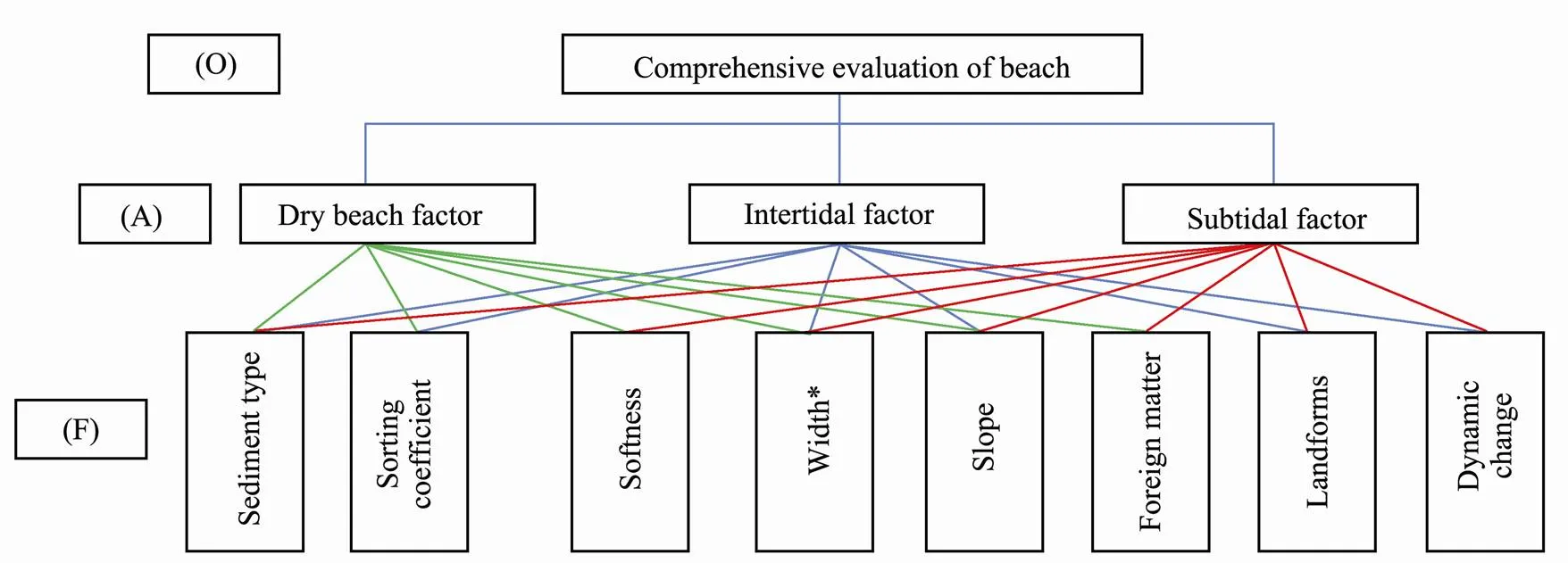
Fig.3 Establishment of beach-quality index system. The width of the subtidal zone refers to the distance from the mid-tide line to the 1.5m water depth line.
4.3 Quantification of Assessment Factors and Scoring Criteria
Referring to the standard of beach quality assessment and rating (HY/T 254-2018) and the assessment system and scoring standards of Li. (2000), Sun and Wang (2012), Wang. (2017) and combined with the actual situation of Yangkou Beach in Qingdao, five scoring gra- des of each factor were divided, and scores were determined based on grade of the assessment factor (Table 4).

Table 4 Beach quantitative rating of assessment factors in Yangkou Qingdao
Note:*Refers to the distance from the mid-tide line to the 1.5 m water depth line.
4.4 Determination of Assessment Factor Weight
The method for determining the weight of assessment factors was as follows: First, all factors were scored in accordance with the established Yangkou Beach quality assessment index system and scoring principles by an experienced expert, and the abnormal value in all scores was eliminated. Then, the weights of these factors were calculated by an AHP. Tables 5–8 show the calculation results of the target layers.
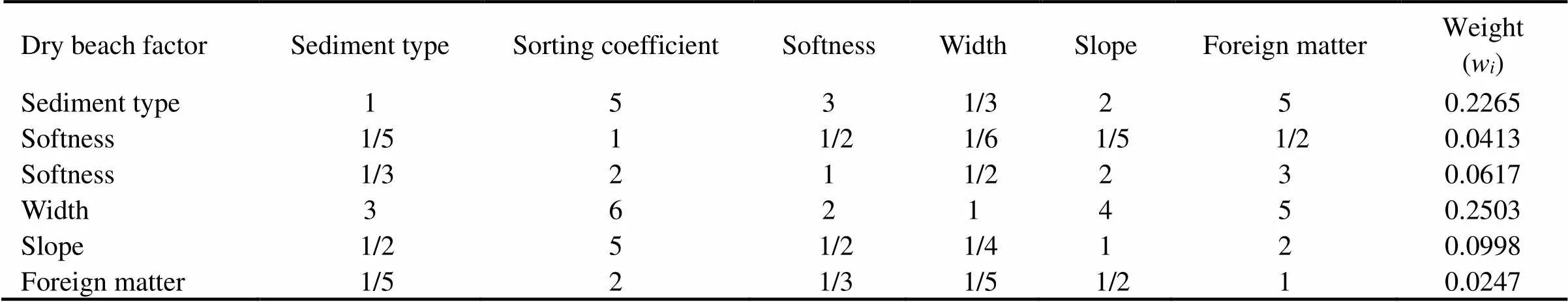
Table 5 Comprehensive assessment of dry beach quality
Notes: Consistency ratio of judgment matrix (0.06); weight of total target (0.2605).
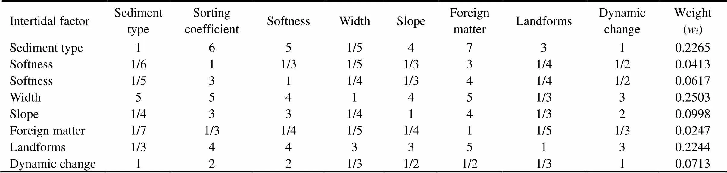
Table 6 Comprehensive assessment of intertidal zone quality
Notes: Consistency ratio of judgment matrix (0.0014); weight of total target (0.6333).
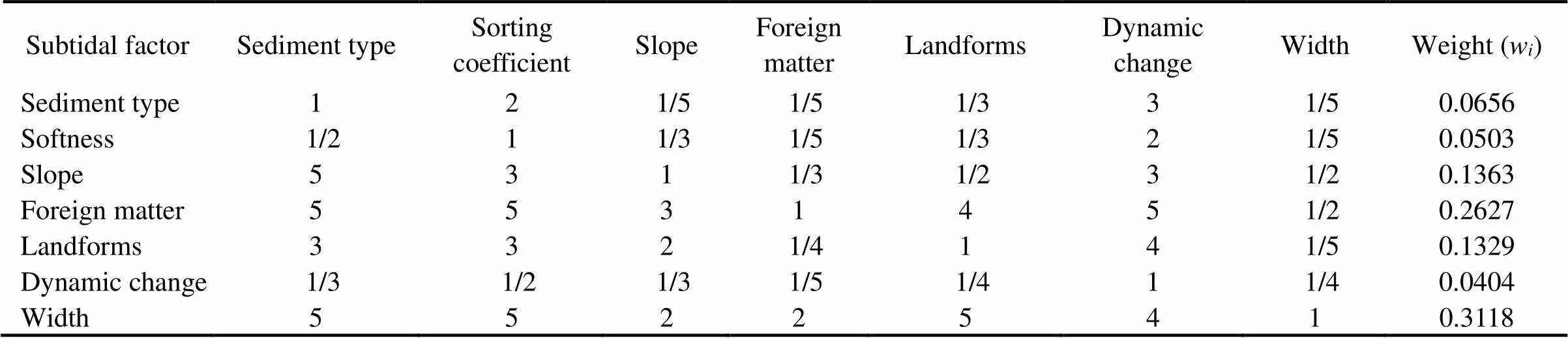
Table 7 Comprehensive assessment of of subtidal zone quality
Notes: Consistency ratio of judgment matrix (0.00811); weight of total target (0.10623).

Table 8 Comprehensive assessment of beach quality
Notes: Consistency ratio of judgment matrix (0.0372); weight of total target (1).
The matrix is multiplied based on the target and sche- me layers to obtain the weight list of all assessment factors (Table 9). It shows that width is the most important factor affecting the quality of the dry beach and intertidal zone, followed by sediment type. The most important factors affecting the quality of the subtidal zone are the width and foreign matter, followed by the beach slope. This result was in line with the opinion of the majority. The AHP is a very useful tool for beach quality assessment.
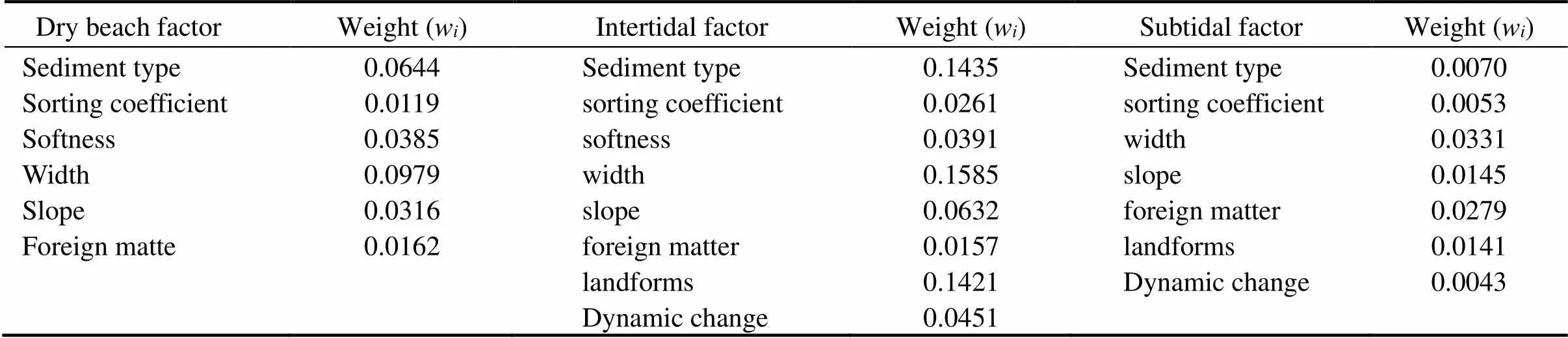
Table 9 List of assessment factor weights
4.5 Comprehensive Assessment of Beach Quality
Based on the survey data of 12 profiles of Yangkou Beach, the actual score of each assessment factor of the dry beach, intertidal zone, and subtidal zone was calculated using the corresponding assignment standard in Table 4. Then, the comprehensive beach quality score of each profile was calculated using the following formula.

whereis the comprehensive score of beach quality,Wdenotestheweight of theth assessment factor,Prefers to thescore of theth assessment factor, and Nis thenumber of assessment factors.
After calculation, the results shown in Table 10 were obtained.
Based on the scoring results, the beach quality was divided into four ratings: excellent (>8.5 points), good (8.4–7.0points), medium (6.9–5.5points), and poor (<5.5 points). According to the comprehensive score and assessment criteria, the beach quality of Yangkou can be divided into four grades: A: excellent, B: good, C: me- dium, and D: poor. The 1.5m isobath is the lower boun- dary, the land boundary of the dry beach is the upper boundary, and the middle line between each profile is the left and right boundary. The plane distribution of beach quality was determined (Fig.4). Excellent-quality areas are distributed in the middle of Yangkou Beach, the good- quality ones north of the bay, the medium-quality ones on the top and south of the bay, and the poor-quality the northernmost end of the beach.
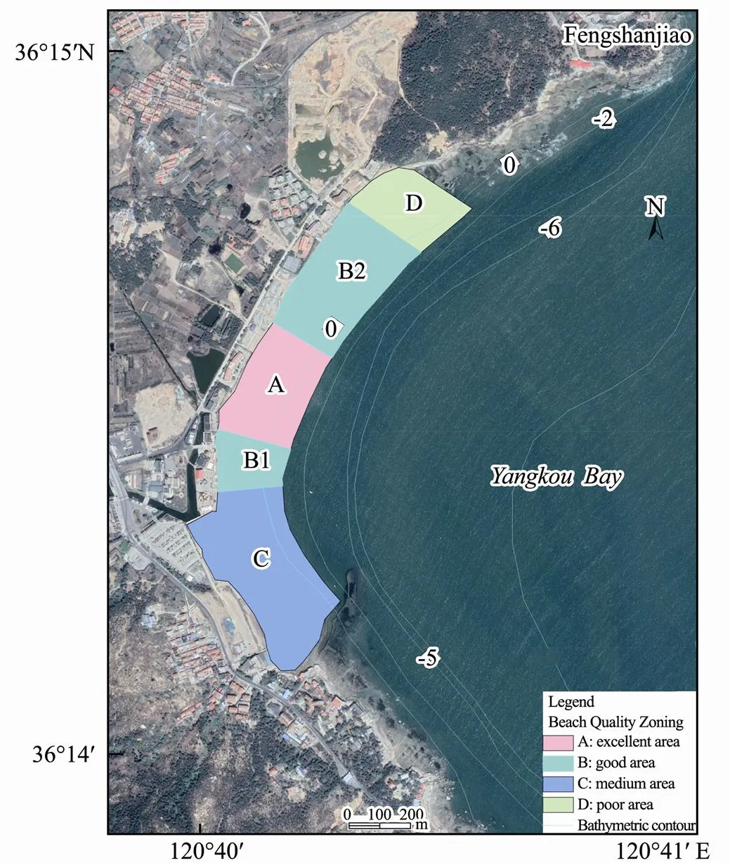
Fig.4 Map of quality zoning plan of Yangkou Beach, in Qingdao.

Table 10 Final assessment scores of beach quality of each profile
5 Analysis and suggestions
5.1 Characteristics of Each Zone
High-quality area (A): Area A, which has a 5.6ha area and covers 19.2% of the whole beach area, is located north of the entrance of Yangkou Beach. It is characterized by the following contents: dry beach width of 40–63m, flat terrain, no stacking of foreign matter, and sediment composed of loose, well-sorted medium-fine sand. The width of the intertidal zone is approximately 100m, its slope is less than 2%, no floating body and other foreign matters are present, and the sediment is composed of medium to slightly dense and well-sorted fine sand. The slope of the subtidal zone is between 2% to 5%, the sedi- ment is composed of well-sorted fine sand, and no micro geomorphic phenomena, such as underground ditches and reefs, nor foreign matters can be observed. Its dynamic change is small and stable. The subtidal zone is suitable for tent building, walking, running, and other entertainment.
Good quality area (B): Area B, which has a 9.88 ha area and covers 33.9% of the whole beach area, is located on both sides of area A. It is divided into north (B2) and south (B1) areas. Area B is characterized by the following contents: a dry beach with a width between 25–46m, a flat terrain, sediment composed of well-sorted to medium-soft and loose medium sand, and some foreign objects. Its intertidal zone is around 110m wide and can be divided into high- and low-tide zones based on the tide level. The width of its high-tide zone is approximately 10 m, and the gradient is 10%. The sediment is composed of gravelly sand. The width of its low-tide zone is approximately 100m, and the gradient is less than 2%. Tidal ditches with a width of 1–2m have developed in this area (Fig.5). The sediment is composed of well-sorted, medium-soft, and dense fine sand; the gradient of the subtidal zone is 2%–5%. The sediment is composed of well- sorted and slightly dense fine sand. No micro geomorphic phenomena, such as ditches and reefs, can be observed, but foreign matters, such as yachts and floating docks, are present. The beach dynamic changes are small and stable. Given the appearance of large tidal creeks, the traffic capacity will be affected, and the underwater movement may encounter the risk of rip currents.
Medium-quality area (C): Area C is located south of Yangkou Beach with an area of 9.81 ha, accounting for 33.6% of the whole beach area. It is characterized by the following contents: dry beach width between 0 to 35m, a lagoon channel 1.5–2.0m in width, and a greatly fluctuating terrain. The sediment is composed of loose gravel sand. Although the width of the intertidal zone is between 130 to 200m, many foreign matters, such as bricks, gravel, and tidal ditches, are developed, and reefs and artificial breeding rafts are found in the subtidal zone, which is only suitable for walking. Under the action of tidal current, the beach in the whole area changes greatly and becomes unstable.

Fig.5 Tidal gully landform in good quality area.
Poor quality area (D): Area D is located north of Yang- kou Beach with an area of 3.87ha, accounting for 13.3% of the whole beach area. It is characterized by the follow- ing contents: several dry beaches that have almost disappeared due to coastal erosion and dry beach locations full of foreign goods. The width of the intertidal belt is approximately 80m, the slope is 3%, reefs and gravel zones are present (Fig.6), the terrain is undulating, and the sediment is composed of poorly sorted gravel sand. Subtidal microgeomorphic phenomena, such as trenches and reefs, can be observed. The beach in the whole area exhibits a large dynamic change, and some evident scouring phenomena occur on the beach due to the existence of the reef in the subtidal zone.

Fig.6 Beach landform in poor quality area.
5.2 Suggestions Based on Quality Assessment Results on Beach Management
The quality of Yangkou Beach is controlled by the wid- th and slope of the beach, type and softness sorting coefficient of the sediment, foreign matter, geomorphic type, and dynamic changes of beach profile according to the above analysis. The width, sediment type, and geomorphic type of Yangkou Beach constitute the main controlling factors from the weights determined by AHP. In the excellent-quality area, the whole beach is wide, and its terrain is flat. All sports, including volleyball, running, and swimming, are suitable for tourists. In the good-qua- lity area, the dry beach is slightly narrow, the small tidal gully landform developed on the intertidal and subtidal zone composed of moderately soft fine sand, and leisure and sports, such as walking and running, are suitable for tourists. Fixed drainage ditches or underground culverts should be built to reduce the tidal gully.In the medium- quality area, the dry beach is narrow, a small amount of foreign matter and tide ditches are present in the intertidal and subtidal zones composed of poorly sorted medium sand, and walking activities are suitable for tourists. Fix- ed drainage ditches or underground culverts must be built for lagoon drainage and repair of the beach surface with the help of beach sediment movement to increase attractiveness. In the poor-quality area, the dry beach is very narrow, and many foreign matters, such as bricks and rock, wide tidal ditches, and poorly sorted gravel, are found in the intertidal zone. Reefs are found in the subtidal zone, and leisure and sports are unsuitable. Sand must be supplied, and the foreign matter and gravel in the intertidal zone must be cleaned to improve the beach qua- lity.
6 Conclusion
Based on the detailed study and analysis of eight influencing factors of three natural geomorphic attributes of 12 survey profiles of Yangkou Beach in Qingdao, this paper established a beach quality assessment index system and assessment standard of Yangkou, determined the weight of the eight influencing factors in their geomorphic attributes using the AHP. We calculated the comprehensive score of each profile and obtained the following conclusions:
1) The Yangkou Beach quality in Qingdao is controlled mainly by the width, sediment type, and slope of the beach. The comprehensive beach quality is divided into excellent-, good-, medium-, and poor-quality beach areas.
2) The beach quality assessment is a very useful tool for building beautiful beaches. Some measures can be used to improve beach quality based on assessment suggestions. Implementation of corresponding measures to increase the score of the main controlling factors is an effective way to improve beach quality.
Acknowledgements
This research was supported by the Intercollegiate Cooperation Plan of Innovation and Entrepreneurship Train- ing Program for College Students of Beijing City (No. 202211012).
Bombana, B., and Ariza, E., 2018. Clarifying some assumptions of coastal management: Analysis of values and uncertainties embedded in beach quality indexes., 91 (5): 376-385.
Bombana, B., and Ariza, E., 2019. A double-loop process for beach quality index construction: Approaching the complexity of the Catalan coast., 240 (4): 177-189.
Botero, C., Pereira, C., Tosic, M., and Manjarrez, G., 2015. De- sign of an index for monitoring the environmental quality of tourist beaches from a holistic approach., 108: 65-73.
Cagilaba, V., and Rennie, G. H., 2005. Literature review of beach awards and rating systems. The University of Waikato Hamilton., 24: 1-74.
Che, L., Zhang, Y. M., Wang, J. C., and Bai, M. S., 2020.A new method for deriving weights in group fuzzy analytic hierarchy process and evaluation measures., 53 (2): 7941-7946.
Díaz, H., Teixeira, A. P., and Soares, C. G., 2022. Application of Monte Carlo and Fuzzy Analytic Hierarchy Processes for ranking floating wind farm locations., 245: 1-10.
Fernando, M., and María, A. P., 2022. Are blue flags a good indicator of the quality of sea water on beaches? An empirical analysis of the Western Mediterranean Basin,,330: 129865.
Gao, F., 2019. The Evaluation of Beach Quality from the Perspective of Tourist Perception: A Case Study., (3): 38-45 (in Chinese with English abstract).
Gisela, G. M., José, A. A., and Renato, A. M. S., 2017. Evaluation of beach quality as perceived by users,. 61 (1): 161-175.
Goda, L., and Thomas, P., 2021. Management priorities from tourists’ perspectives and beach quality assessment as tools to support sustainable coastal tourism., 208: 105646.
Hall, C. M., 2001. Trends in ocean and coastal tourism: The end of the last frontier., 44: 601- 618.
Houston, J. R., 1996. International tourism and US beaches., 4: 3-4.
Hu, B. B., Duan, J. H., and Meng, W. Q., 2020. Construction and application of quality evaluation method for seawater bathing beaches resources in China., 1-10.
Klein, Y. L., Osleeb, J. P., and Violat, M. R., 2004. Tourism- generated earnings in the coastal zone: A regional analysis., 20 (4): 1080-1088.
Lee, P. Z., 1994. The submarine equilibrium profile: A physical model., 10 (1): 1-17.
Li, S. J., Ma, Q., and Zhang, Z. W., 2017. Assessing beach quality according to beach users’ perceived perspective a case study in Qing’ao Bay, Shantou, Guangdong., 36 (6): 832-837 (in Chinese with English abstract).
Li, Z. H., Ke X. K., and Zhou, L. F., 2000. The appraisal system of beach tourism resources., 15 (3): 229-235 (in Chinese with English abstract).
Liu, Y. J., Zhang Z. L., and Ni, T. N., 2009. Study on bathing beaches suitability evaluation with Shandong as an example., 14: 70-73 (in Chinese with English abstract).
Ludovic-Alexandre, V., Franck, M., and Jean-Claude, B., 2011. Using a delphi process and the analytic hierarchy process (ahp) to evaluate the complexity of projects., 38 (5): 5388-5405.
Lu, X., Zhang, C., and Shi, J., 2021. Tourists accident database and accident characteristics of beach tourism in China., 38 (6): 3-11 (in Chinese with English abstract).
Micallef, A., 2003.–, The Gaia Foundation, Malta, 1-47.
Micallef, A., and Williams, A. T., 2004. Application of a novel approach to beach classification in the Maltese Islands., 47: 225-242.
Morgan, R., 1999. A novel, user-based rating system for tourist beaches., 20 (4): 393-410.
Nelson, C., and Botterill, D., 2002. Evaluating the contribution of beach quality awards to the local tourism industry in Wale-The Green Coast Award., 45 (2): 157-170.
Nelson, C., Morgan, R., Williams, A. T., and Wood, J., 2000. Beach awards and management., 43 (1): 87-97.
Panchal, S., and Shrivastava, A. K., 2022.Landslide hazard assessment using analytic hierarchy process (AHP): A case study of National Highway 5 in India., 13: 101626.
Penn, J., Hu, W. Y., Cox, L. D., and Kozloff, L., 2016. Values for recreational beach quality in Oahu, Hawaii., 3 (1): 47-62.
Roca, E., and Villares, M., 2008. Public perceptions for evalu-ating beach quality in urban and seminatural environments., 51 (4): 314-329.
Roca, E., Riera, C., and Villares, M., 2008. A combined asses- sment of beach occupancy and public perceptions of beach quality: A case study in the Costa Brava, Spain., 51 (12): 839-846.
Scott, T. M., Russell, P. E., and Masselink, G., 2011. Rip current hazards on large-tidal beaches in the United Kingdom.. Leathman, S., eds., CRC Press, New York, 225- 243.
Shadmaan, S., and Islam, A. I., 2021. Estimation of earthquake vulnerability by using analytical hierarchy process., 1: 153-160.
Short, A. D., and Hogan, C. L., 1994. Rip currents and beach hazards: Their impact on public safety and implications for coast manage., (12): 197-209.
Suciu, M. C., Tavares, D. C., and Costa, L. L., 2017. Evaluation of environmental quality of sandy beaches in southeastern Brazil., 119 (2): 133-142.
Sun, J., and Wang, Y. H., 2012. A review of beach quality rating systems., (2): 153-159 (in Chinese with English abstract).
Wang, Y. H., Sun, J., and Zhu, Z. H., 2017. Building and application of quality evaluation system a beach: A case the south Shandong Province., (3): 260-267 (in Chinese with English abstract).
Williams, A. T., and Morgan, R., 1995. Beach awards and rating systems., 63 (4): 29-33.
Yu, F., Cai, F., Li, W, J., and Dong, A., 2011. Discussion on beach quality standards rating system in China., 26 (4): 541-551 (in Chinese with English abstract).
Zheng, J. Y., Qi, Z. Y., and Li, X. L., 1998. The environmental quality assessment on the bathing beaches in south sea Shore of Qingdao City., 17 (1): 66- 72 (in Chinese with English abstract).
(May 3, 2022; revised October 5, 2022; accepted November 12, 2022)
© Ocean University of China, Science Press and Springer-Verlag GmbH Germany 2023
Corresponding authors. E-mail: jingyi_w@bupt.edu.cn
(Edited by Ji Dechun)
杂志排行

Journal of Ocean University of China的其它文章
- The Subduction Structure Beneath the New Britain Island Arc and the Adjacent Region from Double-Difference Tomography
- Differences of Polygonal Faults with Irregularly Polygonal Geometries: A Case Study from the Changchang Sag of Qiongdongnan Basin, Northern South China Sea
- Characterization of Bacterial Communities in Aerosols over Northern Chinese Marginal Seas and the Northwestern Pacific Ocean in Autumn
- Role of Resuspended Sediments as Sources of Dissolved Inorganic Phosphorus Along Different Dimensions in the Subei Shoal, South Yellow Sea, China
- Pharmacokinetics of Enrofloxacin and Its Metabolite in Carp (Cyprinus carpio) After a Single Oral Administration in Medicated Feed
- Histone Deacetylation Modifier Induced One New Resorcylic Acid Lactone 7′(Z)-zeaenol from the Zoanthid-Derived Fungus Cochliobolus lunatus