西伯利亚永冻区天然气生产与运输设施建设和运营过程中的土工风险
2014-03-19VeraSamsonovaMaksimBerezhnoiNataliaReutskikh
Vera Samsonova,Maksim Berezhnoi,Natalia Reutskikh
(1.俄罗斯科学院西伯利亚分院麦尔尼科夫冻土研究所,雅库茨克677010,俄罗斯;2.OAO VNIPIgazdobycha,萨拉托夫410000,俄罗斯)
0 Introduction
Hazardous natural,natural-industrial and geotechnical factors and negative natural and geotechnical consequences of interaction of foundations of buildings and structures with the environment,which can cause failures or degrade operational reliability of the support element of geotechnical systems,are geotechnical risks.The purpose of the geotechnical studies and surveys while designing facilities in the permafrost zone is to assure mechanical safety and operational reliability of buildings and structures foundations with due account of geotechnical risks,and risks mitigation to the acceptable level at all stages of the facilities life cycle.The main targets are the following:selection of areas in the pipeline routing zone or in the zone of the facility site,where,on the basis of surveys materials,there are conditions for potential buckling of supporting soils or such conditions may occur during the period of construction and operation of the facility,and under climatic conditions changes.That means that identification of the actual(current)and potential geotechnical risks is being performed.The result of fulfillment of these targets is the basis for the development of optimal technical solutions and preventive measures needed to stabilize the supporting soils or to provide engineering protection of the territory,as well as to design geotechnical monitoring networks during the facility operation.The most vital is assessment of risks associated with geotechnical problems of interaction of foundations of buildings and structures with the environment in case of climate fluctuations.Identification of areas directly or potentially vulnerable to changes of significant factors ofenvironmentalallows studying and evaluating geotechnical risks using methods and techniques of geocryological forecast[1].The methods of analysis,developed as a scientific support or within the projects of OAO VNIPIgazdobycha are used for identification and differentiation of geotechnical risks.Cryogeotechnological forecast methodology developed by Popov A.P.is used in the study and assessment of geotechnical risks by meansofnumericalgeocryologicalforecast[1-5].
1 Materials and methods
Geotechnical risks of the territory are divided into engineering-geological,engineering-geocryological,geocryological-climatic,since a certain set of criteria and methods is required for their analysis and assessment.The actual geotechnical risks are defined by upto-date(at the moment and period of surveys)engineering and geological and engineering and geocryological conditions and characteristics,which include features of supporting soil cross-section,displays and dynamics of hazardous exogenous and cryogenic processes within the territory and at the adjacent areas.
Potential geotechnical risks are identified on the basis of assessment of risk of dynamics of engineeringgeologicaland engineering-geocryologicalconditions and parameters under influence of geotechnical,industrial loads or in case of climate fluctuations.
Within analysis of actual and potential engineering-geological risks(identification of natural,natural and man-made,industrial geotechnical risks):
1)In the permafrost zone the main method is typification of engineering and geocryological conditions (analysis and geotechnical assessment of engineeringgeocryological risks)— the assessment of potential risks of the building/structure foundation cross-section (technicalcondition,composition,propertiesand characteristics of soils and type of the cross-section in general)for development of hazardous cryogenic and other exogenous processes during operation(i.e.vulnerability of the building/structure foundation in case of direct and indirect impact)[6-7,9-10].
At the same time the presence and intensity of their display in the area and at the sites of facilities prior to construction are considered as an indicator of their potential display,activation and development(predisposition of the territory to their natural dynamics),in addition,landscape risks analysis for slope processes determination shall be performed for pipelelines[11].
2)In geotechnical assessment of engineering and geological conditions in the areas and zones of high seismic activity the evaluation values shall be taken into account and included into the characteristics for typification of geotechnical specific features of supporting soils of facilities;the seismic risk is considered as a specific component of the general engineering and geological risk,depending on the possibility of engineering-geocryological or permafrost-climatic risks.
3)The analysis and typification of karst risks for buildings/structures foundations shall be performed in the areas of carbonates and other karst rocks occurrence,at the same time the presence and intensity of such rocks display in the area and at the facility sites prior to construction are considered as an indicator of potential risks occurrence,activation and development (predisposition of the territory to the natural dynamics of karstification).Presence of signs of recent karstification activity on the surface,buried karst formations and associated sediments,modern deep seated karst shall be taken into account and included in the characteristics in typification of geotechnical specific features of supporting soils of the facilities.
The risk of karst activation and development is considered as a specific component of the general engineering and geological risk,depending on the possibility of realization of engineering and geocryological or permafrost-climate risks.
Combination and space-time integration of several types of engineering and geological risk,increasing the uncertainty of location and time of hazardous events realization,dramatically aggravates geotechnical evaluation of the zone,site or territory of construction.
The main criterion is sustainability of the foundation(set and variability of characteristics of bearing capacity and deformation properties under natural,geotechnical,natural and geotechnical and industrial factors and loads)in process,and in the zone of its interaction with the environment.The construction site has its own specific features determined by regional and local features of genesis and development of the geological environment over time.Nevertheless,approbation of methodology for different facilities and stages of design works proves that the presence of a common criterion for evaluation of mechanical safety of support component enables use of a number of methods of typification of conditions and techniques of engineering and geological risks(hazards)analysis as basic ones,adapting them to the tasks of a particular stage of design works.
Materials of engineering surveys with the following basic(universal)methods of analysis are used to identify the actual(modern)and potential geotechnical risks:
1)Typification of cross-section risks.Areas with converging,non-converging,stratified(by location of permafrost in relation to the seasonally thawed layer and by the presence of new formations of permafrost),thawed type of the cross-section considering parametric characteristics(temperature of permafrost rocks and thickness of seasonally thawed or seasonally permafrost layer)shall be selected and then combined into 4 groups,based on the lithological heterogeneity of the cross-section and the specific geocryological features,then typification of engineering and geological conditions of the cross-section shall be performed,followed by grouping according to significant characteristics of engineering and geological elements(ice content,heaving properties of soils,presence of cryopegs and deposits of underground ice).
2)Identification and analysis of activity of current exogenous processes and intensity of physical and geological cryogenic processes.This analysis is performed using materials(plan layouts and cross-sections)of surveys,data of route survey,monitoring and stationary observations,as well as asynchronical aerial and space surveys.
3)Landscape risks analysis.It includes general morphometric differentiation(typification)of the territory surface into areas(terrain types),different in conditions and set of processes of modern denudationwatersheds,slopes,topographic lows,as well as specific differentiation of slopes and typification of their risks(groups of types of stows)depending on the slope and local base level of erosion.
4)Techniques of cryogeotechnological,retrospective and forecast simulation for thermotechnical calculations of rates of freezing and thawing of supporting soils and analysis of dynamics of roof of permafrost soils in natural and natural-geotechnical conditions,thermal impact of buildings/structures on the supporting soils,taking into account changes in climate or variability in significant characteristics.
2 Discussions and conclusions
Using the method of cross-section risks typification there was developed a method for evaluation of the specific risk, applied for the pipeline network‘Yamal’[9],evaluation of effectiveness of implementation of technical solutions for the underground oil pipeline section was made on the basis of materials of geotechnical monitoring at the stage of operation of oil transportation system from Vankor field[7,10].
In assessing geotechnical risks for the facilities located in different regions of the permafrost zone it was revealed that it is appropriate to select the main specific risk of development of the most hazardous processes for building/structure among the actual and potential engineering and geological processes,specific for the studies territory.The specific defined risks are the following:Suffusion,thermodenudation,permafrost and hydrogeological and other potential risks being a part of the actual general engineering-geological,engineeringgeocryologicaland permafrost-climatic geotechnical risks.
Taking into account regional specific features of the construction territory for a group of facilities designed by OAO VNIPIgazdobycha,the following analyses were performed:
-Landscape risks analysis for the development of slope processes as part of surveys at the stage of feasibility study[11],typification and analysis of set of engineering and geocryological risks at the design stage[1]and thermodenudation risks(according to deposit forming ice)-for the Yamal part of the trunk gas pipeline Bovanenkovo-Ukhta(Table 1);
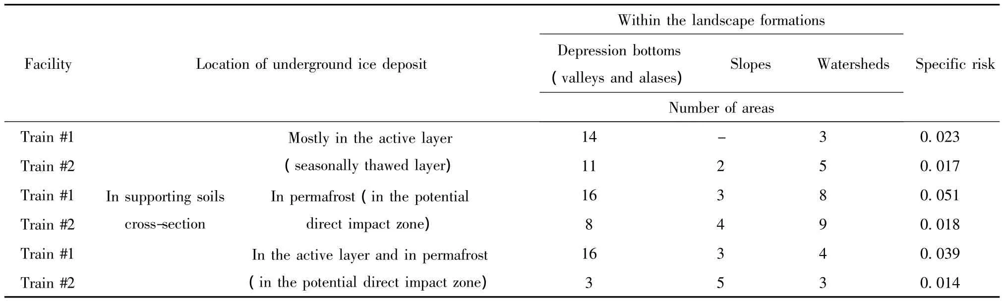
Table 1 Characteristics of thermodenudation risk in the zone of the first trains of the trunk gas pipeline Bovanenkovo-Baidaratskaya
-Analysis of the set of engineering and geocryological risks-for the facilities of Bovanenkovo and Kharasaveyskoye fields in geotechnical studies within the framework of R&D of the Innovative program of OAO VNIPIgazdobycha,analysis and identification of activity of modern physical and geological processes and thermodenudation risk within the surveys at the stage of feasibility study[11,16]and detail documentation for facilities of Gas Field 3 of Bovanenkovo field;
-Analysis of the risks of changing permafrost and hydrogeological conditions(for the areas of distribution of Verkholenskaya and Ilginskaya suites of the Middle and Upper Cambrian with construction properties of soils which sharply change in case of thawing,for karst and suffosion hazardous areas)-at the stage of feasibility study,design and detail documentation stages of the facilities of Chayanda and Kovykta fields(Tables 2,3),at the design and detail documentation stages of the trunk gas pipeline Power of Siberia,as well as for field and pipeline structures in the zone of development of the permafrost roof lowering process on the territory of facilities in the Western Siberia[6,12].
Table 3 shows specific frequency of areas for the entire pipeline route.Given that,frequency of areas with potential engineering and geocryological risks in the zone of solid permafrost distribution varies from 0 to 4 within 10 km,with the potential geodynamics from 1 to 9 within 10 km.In the zone of interrupted permafrost distribution frequency of areas with potential geodynamics is 4/10 km,in the zone of island permafrost distribution it varies from 0 to 4/10 km.
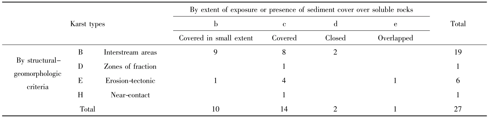
Table 2 Number of areas with different karst sub-types in the zone of routing of oil pipeline Chayanda-Talykan with permafrost formation
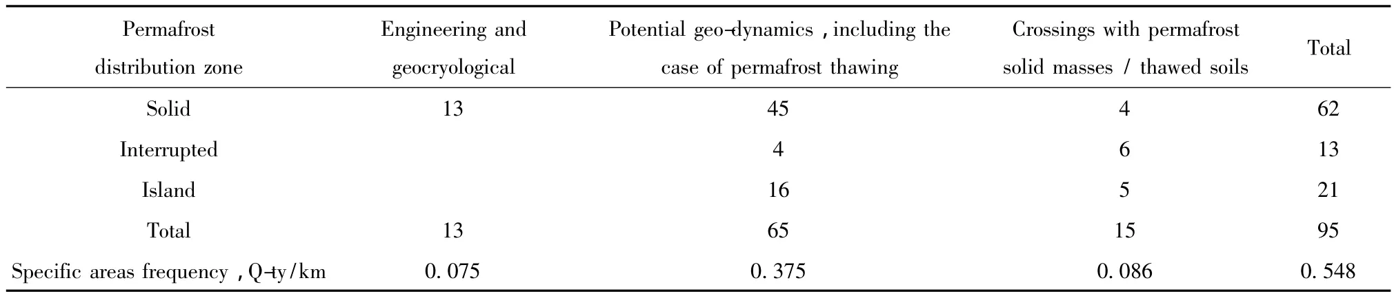
Table 3 Number of areas in the zone of the oil pipeline Chayanda-Talykan with geotechnically hazardous engineering-geological conditions
In the research report developed by Drozdov et al.,2010 there were presented summarizing materials of geocryological monitoring,starting from the second half of the 1970-ies in the Urengoy field.It is shown that rise of soil temperature is typical for this field in the recent decades.In certain landscapes of the southern part of its territory changes in temperature mode are accompanied by the permafrost roof lowering.
Comparative analysis of materials of surveys and geotechnical monitoring of different years shows that the same process occurs in certain parts of Zapolyarnoye field(Table 4).The main reason is the change in the regime of snow accumulation in this part of West Siberian forest-tundra.According to the data of Novy Urengoy meteorological stations snowy winters are observed in the last decade(Table 5).
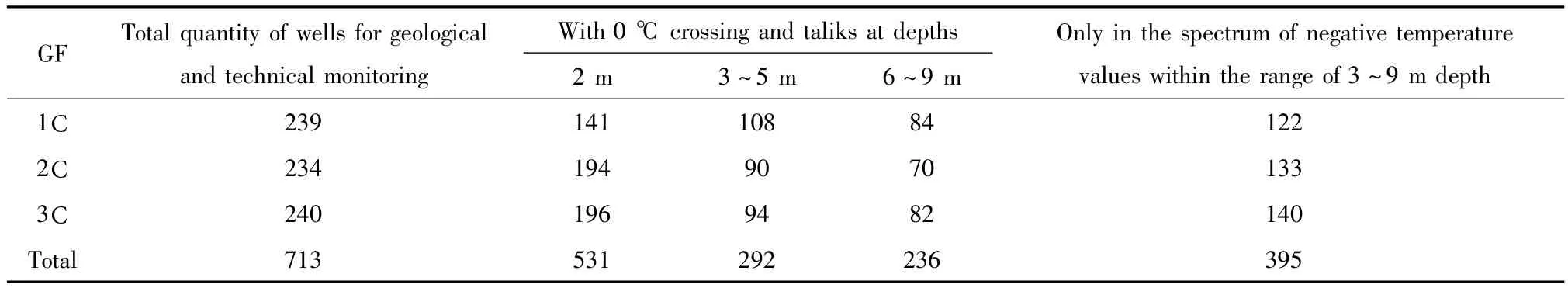
Table 4 Number of geotechnical monitoring wells(GMW)with phase transitions in the annual heat exchanges layer in the foundations of clusters'sites of Zapolyarnoye field,pcs
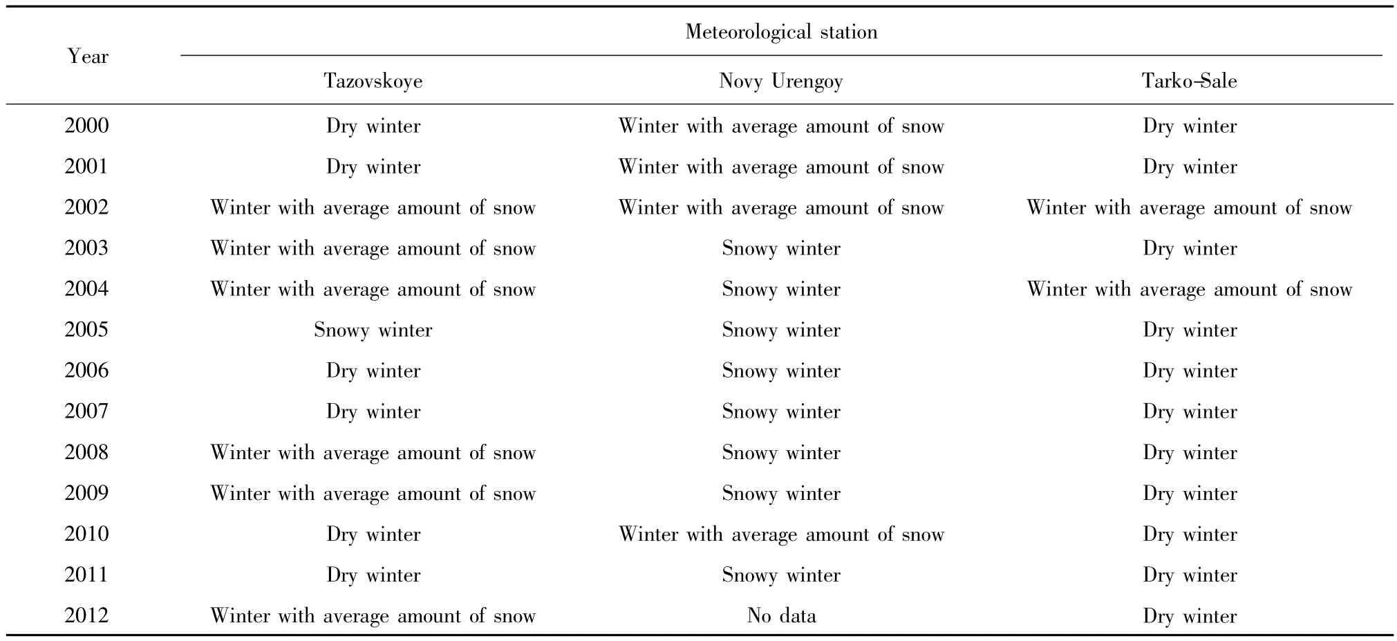
Table 5 Winter type*by the maximum snow cover depth as of April,15
When making thermotechnical calculations for the territory of Chayanda field,air temperature trends since 1955 were taken into account to identify the contribution of significant heat transfer conditions on the surface for the current state and to make a forecast evaluation of natural dynamics of the upper horizons of the permafrost zone.According to evaluations by various authors for the meteorological station Olekminsk having a long series of observations,the trend of average annual air temperature in this region has a value of 0.4℃/10 years[8,13-15].Forecast simulation showed that for half a century there was an increase in soil temperature in the spectrum of negative values and in case of maintaining the values of the trend in the coming years here will start permafrost roof lowering in the watershed areas covered by middle taiga forests where the soil temperature at the time of surveys(2012~2013)had the value of about minus 0.5℃.Data of Komaka meteorological station located within the field were used as basic.There are no trends of changes of snowiness of winters for this region,therefore,the major factor of permafrost roof lowering here is the increase of air temperature.It should be noted that the air temperature trend values are close for the areas under consideration.For the fields of Western Siberia it was indicated in the work by Pavlov et al,2007,that it was 0.05℃ /year,for Chayanda field-0.04℃ / year.
Obviously,the uncertainty of the reaction of the support component of the facility,located in a specific area,on a number of natural processes determined by global or regional factors,resulting in changes in permafrost and climatic conditions,shall be considered as the geotechnical risk in construction and operation of both pipeline structures and field facilities.Expediency of selection,analysis and assessment of permafrost and climatic geotechnical risks was highlighted in the development of sections of Soil thermal stabilization and well interventions of the‘Project of reconstruction and modernization of Zapolyarnoye field’in 2011~2012,as well as R&D section‘Creating a database for the geocryological forecast of the thermal state of supporting soils of foundations of field facilities and hydrocarbons transportation systems in the Western Siberia’,implemented under the Innovation program of OAO VNIPI gazdobycha in 2012~2013.In addition,there have been developed the principles,approaches and methods for evaluating permafrost and climatic risks,allowing analyzing large volumes of meteorological and geothermal data.It was found that climate changes in the Arctic and Subarctic regions have fluctuating nature and significant spatial and temporal variability,3~7 years and other cycles have a connection with the 11 years and other cycles of solar activity.
This correlation has essential methodological significance for processing of geotechnical monitoring data and setting tasks of forecast simulation of thermal interaction of soil foundations of structures with the environment.While performing analysis of materials of surveys,geocryological and geotechnical monitoring,and while evaluating the results and setting tasks of forecast calculations it is necessary to take into account the cycle nature of solar activity.The arguments for this conclusion were the forecast evaluations of changes in the solar constant[16]and the influence of processes in the solar system upon the Earth's climate[17],as well as the results of the analysis of meteorological data(Table 6~7)and materials of geocryological monitoring at Marre-Sale station,carried out as part of the R&D of the Innovation program of OAO VNIPIgazdobycha.Thermotechnical calculations with warming trends have been used in the sections of Soil thermal stabilization and in well intervention projects of OAO VNIPI-gazdobycha since 2007,and with the trends of warming and cooling of the climate-since 2013.
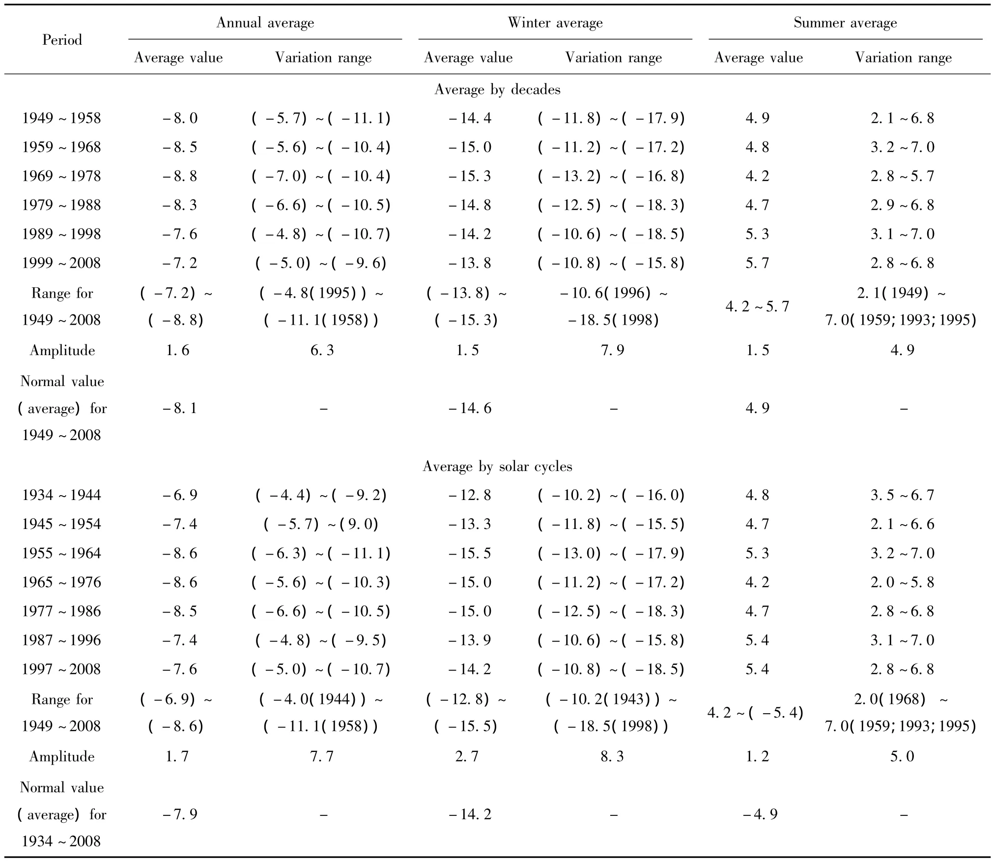
Table 6 Average air temperature by different periods according to the data of Marre-Sale meteorological station
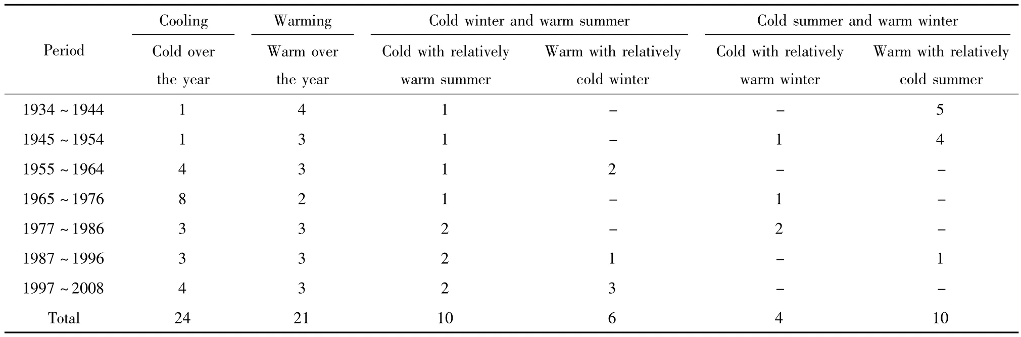
Table 7 Number of years with different trends of deviation from the normal value,1934~2008 (Marre-Sale meteorological station)
However,the analysis of map charts presented in the research works[18-19]proves that in case of change of the period duration by one year,for example,for the Yamal peninsula,there is a significant change in the trend values.Duration of solar cycles for the considered period ranged from 9.7 to 12.6 years.Construction of infrastructure facilities in the Siberian fields corresponded to different phases(increasing,peak,recession and decreasing)of solar activity.Operation of facilities is or may be within 3~4 solar cycles.Analysis of variability of the averaged air temperature within solar cycles is more substantiated;it enables updating of the surveys materials for forecasting and allows evaluating trends of cryogenic processes activity.
[1] Popov A P,Samsonova V V,Usachev A A,et al.Use of the engineering survey standards RSN 67-87 for designing the linear objects of the trunk gas pipeline system'Bovanenkovo-Ukhta'[J].Engineering Survey,2010,4:58-67.
[2] Popov A P,Management of geotechnical systems of gas complex in permafrost zone.Forecast of conditions and realiability support[J].Proceedings of higher education institutions.Oil and gas,2005,4:6-16.
[3] Popov A P.Monitoring of gas pipelines in permafrost[A].The 1st International Workshop on Ceotechnical Engineering in Permafrost Regions Related to Pipeline Construction[C].Fairbanks,2006.
[4] Popov A P,Melnikov V P,Milovanov V I,et al.Techniques providing for operational reliability of bases and foundations of gas production and transportation geotechnical systems and climatevariability in the northern circumpolar region of Russia[A].Paris: International Gas Union Research Conference,2008.
[5] Popov A P,Samsonova V V.Innovative aspects of using natural cryogenic resources for ensuring mechanical safety of buildings and structures in cryolythozone[J].International Journal Ceotechnics,2011,5:4-21.
[6] Samsonova V V,Manukhin B A,Popov A P,et al.Typification geocryological conditions and forecast simulation as a basis for designing geotechnical monitoring systems of pipelines[A].Proceedings of the International Conference'Cryogenic Resources of Polar and Mountain Regions.State and Prospects of Engineering Permafrost Studies'[C].Tyumen:Tyumen State Oil and Gas University,2008,154-157.
[7] Samsonova V V,Pankov O O.Experience in construction and operation of buildings and engineering structures in cryolithozone: Case of Mirny,Yakutia.In:Drozdov DS(ed.)[A].The Tenth International Conference on Permafrost:Resources and Risks of Permafrost Areas in a Changing World(Salekhard,Yamal-Nenets Autonomous District,Russia.June 25-29,2012)[C].Fort Dialog-Iset:Ekaterinburg,2012:492-493.
[8] Romanovsky V E,Sazonova T S,Balobaev V T,et al.Past and recent changes in air and permafrost temperatures in the eastern Siberia[J].Global and Planetary Change,2007,56:399-413.
[9] Ruzov Yu V,Samsonova V V.Cryogenic processes as a risk factor in the operation of pipelines in areas of permafrost soils[A].Proceedings of the International Scientific-Practical Conference on Permafrost Engineering,Devoted to the Twentieth Anniversary of the SPA《FundamentStroyArcos》[C].Tyumen:LLC《City-Press》,2011,361-364.
[10]Mullanurov D R,Samsonova V V.Geotechnical problems of the buried oil pipeline operation in the cryolithozone of the north of western Siberia.In:Drozdov DS(ed.)[A].Ekaterinburg:The Tenth International Conference on Permafrost:Resources and Risks of Permafrost Areas in a Changing World(Salekhard,Yamal-Nenets Autonomous District,2012,412-413.
[11] Samsonova V V,Gubarkov A A,Brushkov A V,et al.Assessment of the dynamics of cryogenic processes and conditions of their development in the area of trunk gas pipeline Bovanenkovo-Baidaratskaya[A].Proceedings of the International Conference‘Cryogenic Resources of Polar Regions’ [C].Tyumen:Salekhard.Tyumen State Oil and Gas University,2007,200-203.
[12] Voroshilina I N,Maramygina M S,Samsonova V V.Forecast of anthropogenic impact on the foundations of structures in surveys in areas with interrupted cryolithozone[A].Proceedings of the International Conference'Cryogenic Resources of Polar and Mountain Regions.State and Prospects of Engineering Permafrost Studies'[C].Tyumen:Tyumen State Oil and Gas University,2008,74-76.
[13] Pavlov A V,Malkova G V,Skatchkov Yu B.The modern trends and evolution of the thermal state of the permafrost zone in climate changes[A].Proceedings of the International Conference 'Cryogenic Resources of Polar Regions',Salekhard[C].Tyumen:Tyumen State Oil and Gas University,2007,34-38.
[14] Pavlov A V.Monitoring of the Permafrost Zone[M].Novosibirsk:Publishing House'Geo',2008:229-234.
[15] Fedorov A N,Ivanova R N,Park H,et al.Recent air temperature changes in the permafrost landscapes of northeastern Eurasia[J].Polar Science,2014,8:114-128.
[16] Abdusamatov K I.Sun Dictates the Earth's Climate[M].St.Petersburg:The publishing company《Logos》,2009:197-201.
[17] Dmitriev A A,Belyazo V A,Gudoshnikov Y P.Rhythmic fluctuations of the Earth natural processes and the gravitational conditionality[M].St.Petersburg:The publishing company of Polytechnic University,2011:232-237.
[18] Sherstyukov B I.Changes,Variability and Fluctuations of Climate[M].Obninsk:The Federal State Budget Institution'The All-Russian research institute–The World Data Center',2011,296.
[19] Sherstyukov B I.Seasonal patterns of climate changes for 1976-2011[A].Proceedings of the Federal State Budget Institution 'The All-Russian research institute– The World Data Center'[C].Analysis of Climate Changes and Their Consequences,2012,3-12.